FaultRock - structural geology, (neo)tectonics and engineering geology
  • Home
    • About me
  • Photos
    • Timor Leste >
      • Timor PhD field work
      • Timor 2016
      • Timor 2017
    • New Zealand >
      • Greendale fault photos
    • Australia >
      • Cape Conran, East Gippsland
      • Cape Liptrap
      • Northern Queensland
  • Publications
    • Journal Articles
    • Conference contributions and industry presentations
    • Popular science
    • Theses and other
  • Research interests
    • Australian Earthquakes
    • Timor mapping project
    • Timor-Leste engineering geology >
      • Diapirs and mud volcanoes
      • Timor-Leste coastal erosion
    • Applied Geology >
      • The Pyramid project
      • Engineering geology
      • Geohazards
    • New Zealand earthquake geology
    • Teaching >
      • Unimelb MGeo >
        • Graduate programs for Engineering Geology
        • Virtual field trip Studley Park
      • Field camp teaching
      • Lectures
      • Useful links
    • Collaborators
  • Contact
  • Blog

Australian earthquakes

Is the Southwest Seismic Zone of Western Australia a fixed zone

The completeness magnitude for earthquakes in Western Australia in the decade prior to the Meckering earthquake is about M3, so the image below shows the progression of earthquakes M>=3 in the subsequent decades. North of Meckering (big purple star at the start of the gif), there is a trend of northeastward migration of seismicity away from Meckering. South of Meckering, the trend is not so obvious but there is still a general sense of migration of seismicity away from Meckering. Note also the fall off of seismicity in the direct vicinity of Meckering.
Picture
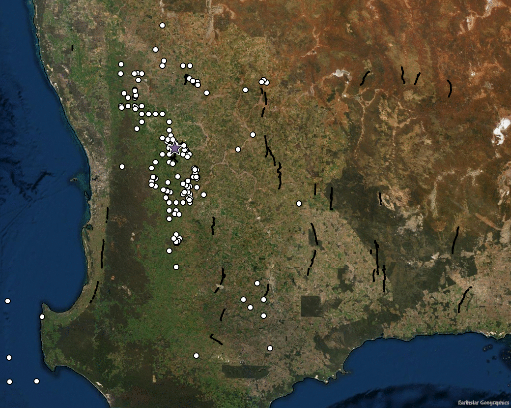
Decadal progression of Western Australian earthquakes. The white dots are pre-Meckering earthquake M>3 and the subsequent animation shows M>3 in 10 year periods since 14 October 1968.
Life is too short to look at ugly rocks
  • Home
    • About me
  • Photos
    • Timor Leste >
      • Timor PhD field work
      • Timor 2016
      • Timor 2017
    • New Zealand >
      • Greendale fault photos
    • Australia >
      • Cape Conran, East Gippsland
      • Cape Liptrap
      • Northern Queensland
  • Publications
    • Journal Articles
    • Conference contributions and industry presentations
    • Popular science
    • Theses and other
  • Research interests
    • Australian Earthquakes
    • Timor mapping project
    • Timor-Leste engineering geology >
      • Diapirs and mud volcanoes
      • Timor-Leste coastal erosion
    • Applied Geology >
      • The Pyramid project
      • Engineering geology
      • Geohazards
    • New Zealand earthquake geology
    • Teaching >
      • Unimelb MGeo >
        • Graduate programs for Engineering Geology
        • Virtual field trip Studley Park
      • Field camp teaching
      • Lectures
      • Useful links
    • Collaborators
  • Contact
  • Blog