
During 2015 I had the good fortune to co-lead a drilling programme at the Pyramid Project, a 100% MGT Resources Ltd owned tenement located on the fault that juxtaposes the Proterozoic Anakie Inlier against the commonly-mineralized Drummond Basin of Northern Queensland. For more information about MGT or the Pyramid Project, contact [email protected], or see the MGT contact page. The drilling results were exceptional because of the following structural observations:
1) Previous drilling campaigns at Gettysberg had focused on the distribution of a line of prospects along the NE-striking basin bounding fault. Drilling programmes were designed to intersect mineralization at a high angle, and assumed that the regional and local (Gettysberg) mineralization trends were the same. (As it happened that was an invalid assumption.)
|
2) The only diamond holes in the most densely drilled Gettysberg prospect of the Pyramid project had both penetrated a single fault that truncated the mineralization. That fault could only strike NW, rather than NE.
3) Old mapping from the 1990s clearly defined a left lateral kink band passing through the prospect, coinciding with the strike of the fault. 4) A stream at the south end of the Gettysberg prospect exposed a wide zone of normal oblique right lateral shear trending ENE. Because the stream flowed E-W, it was subparallel to the preferred WNW-trending drillholes and no holes had ever drilled below the stream. 5) The NW and WSW striking fault sets can be mapped repeatedly throughout the tenement and are usually mutually offsetting. This relationship is known as orthorhombic normal faulting and is caused by 3-dimensional shear (read this paper and this one, and have a look at my home page, which features a beautiful orthorhombic faulted outcrop formed in the same way). Faults that form in this way can be active at the same time and form by slip down the intersection of the two fault planes. 5) Au anomalies in soil surveys were sharply truncated by these two, top-to-north, orthorhombic normal faults. |
Drill design
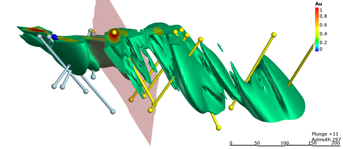
The figure above is a Leapfrog model based on interpolation of the pre-2015 drilling. This previous drilling was all into or out of the figure above. The 2015 drill holes are shown and were designed to test the new 'cross-fault' model. As such, the drilling was generally perpendicular to the diamond drilled fault, and at a high angle to previous drilling campaigns. Similarly oriented holes also targeted the undrilled zone under the faulted stream (see grey drillholes above). Two holes were drilled down-plunge of inferred fault-controlled oreshoots to test their continuity to depth.
Drill results
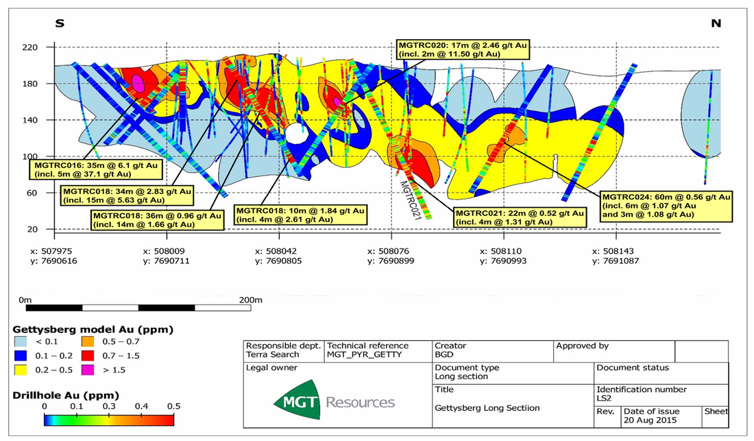
The drilling results spoke volumes about the success of the structural reappraisal. A single one metre interval in MGTRC016 intercepted 146 g/t Au; That hole was drilled below the stream with right lateral faulting. Perhaps more importantly, large high grade (>2 g/t Au) intercepts were reported.
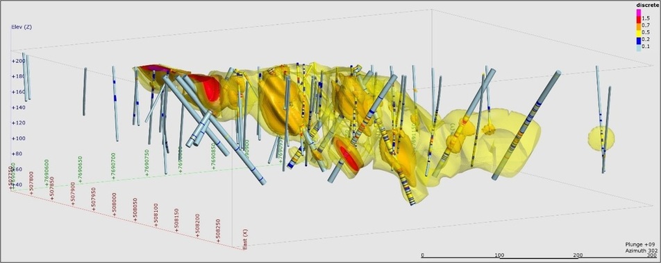
The modelled mineralization after drilling is now substantially thickened in the vicinity of the fault. It clearly steps down across to the north across the faults. Drummond basin sediments are found overlying mineralization in the north, whilst Anakie Metamorphics lie below it in the south. The combined throw on the faults is approximately the thickness of the Ukalunda Formation that lies between the Anakie and Drummond units, and may be several hundred meters. This suggests that the entire Ukalunda Formation is mineralized close to the Drummond Basin margin. The mineralization on the hanging wall side of the fault is open at depth, making Pyramid a very exciting prospect for future exploration!