FaultRock - structural geology, (neo)tectonics and engineering geology
  • Home
    • About me
  • Photos
    • Timor Leste >
      • Timor PhD field work
      • Timor 2016
      • Timor 2017
    • New Zealand >
      • Greendale fault photos
    • Australia >
      • Cape Conran, East Gippsland
      • Cape Liptrap
      • Northern Queensland
  • Publications
    • Journal Articles
    • Conference contributions and industry presentations
    • Popular science
    • Theses and other
  • Research interests
    • Australian Earthquakes
    • Timor mapping project
    • Timor-Leste engineering geology >
      • Diapirs and mud volcanoes
      • Timor-Leste coastal erosion
    • Applied Geology >
      • The Pyramid project
      • Engineering geology
      • Geohazards
    • New Zealand earthquake geology
    • Teaching >
      • Unimelb MGeo >
        • Graduate programs for Engineering Geology
        • Virtual field trip Studley Park
      • Field camp teaching
      • Lectures
      • Useful links
    • Collaborators
  • Contact
  • Blog

Baucau

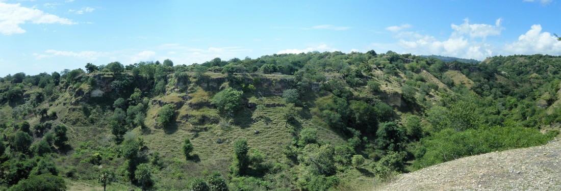
The town of Baucau on the north coast of Timor-Leste is located on the headwall (top edge) of a giant landslide that has partly dismembered the edge of the Baucau Plateau, an extensive plateau formed by uplift of Pleistocene coral terraces. The northern and some of the eastern parts of the nearly 600 m high plateau are fringed by uplifted reefs that record an extended period of uplift at presently poorly-constrained rates and timing. The terraces were examined by Chappell and Veeh and more recently by Nicole Cox, presently of Federation University, Ballarat (red links will take you to the relevant publication).
Picture
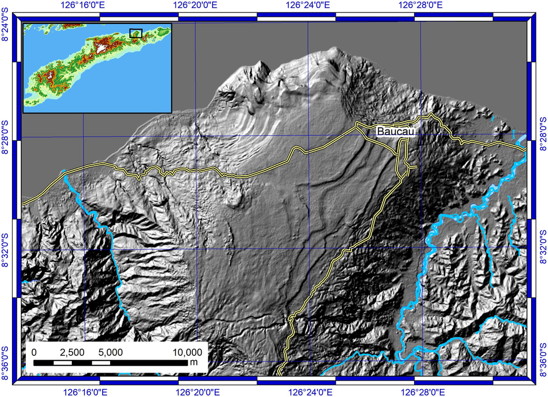
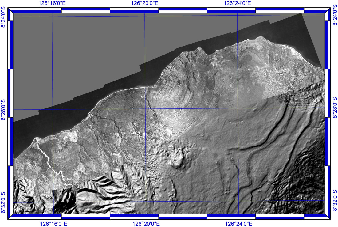
The orthophoto below is derived from a run of 1950s-era monochrome aerial photographs, and illustrates the extraordinary number of individual mappable terraces along the northern margin of the Baucau Plateau. The ALOS 30m DEM shows clearly how the terraces are being progressively destroyed by landsliding, especially along the southeastern margin of the plateau, where synorogenic rocks overlie weak Triassic rocks.
Picture
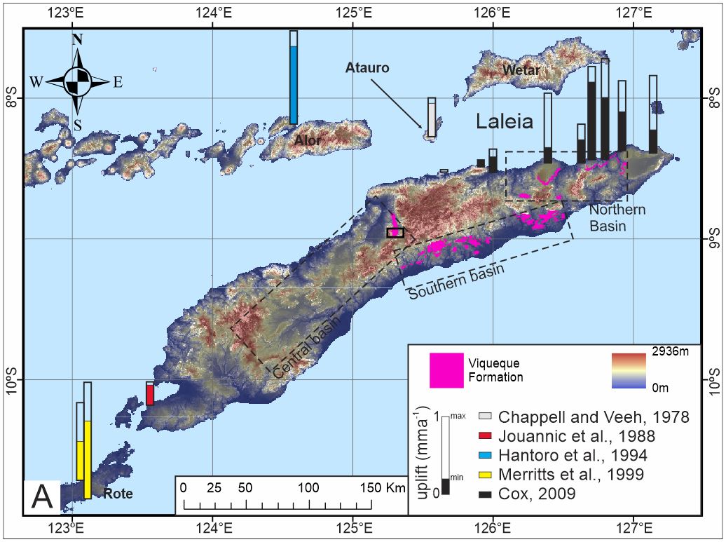
The Baucau terraces are rather typical of the uplift along the strike of the Timor sector of the Banda Orogen. The map/diagram below shows how ubiquitous but variable the Quaternary uplift of the Timor region has been, and the error bars illustrate the extent of the difficulty in defining it. Note the extensive exhumation of the synorogenic Central, Southern and Northern Basins.
Picture
Picture
Picture
The two photos above show the relatively thin coral limestone capping fan-delta gravels
Picture
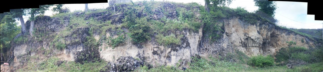
This photo shows an outcrop on the north coast, a few kilometers east of Baucau that shows the rapid lateral and vertical transitions from gravel to coral and back again, reflecting a dynamic environment on the margin of a fan delta. 

The slideshow below shows some details of a typical outcrop of fan delta deposits
Life is too short to look at ugly rocks
  • Home
    • About me
  • Photos
    • Timor Leste >
      • Timor PhD field work
      • Timor 2016
      • Timor 2017
    • New Zealand >
      • Greendale fault photos
    • Australia >
      • Cape Conran, East Gippsland
      • Cape Liptrap
      • Northern Queensland
  • Publications
    • Journal Articles
    • Conference contributions and industry presentations
    • Popular science
    • Theses and other
  • Research interests
    • Australian Earthquakes
    • Timor mapping project
    • Timor-Leste engineering geology >
      • Diapirs and mud volcanoes
      • Timor-Leste coastal erosion
    • Applied Geology >
      • The Pyramid project
      • Engineering geology
      • Geohazards
    • New Zealand earthquake geology
    • Teaching >
      • Unimelb MGeo >
        • Graduate programs for Engineering Geology
        • Virtual field trip Studley Park
      • Field camp teaching
      • Lectures
      • Useful links
    • Collaborators
  • Contact
  • Blog