
 http://www.cooperativeindividualism.org/cartoon_my-home-is-my-castle.jpg http://www.cooperativeindividualism.org/cartoon_my-home-is-my-castle.jpg Most people in western society drive. Drivers are taught and required to be hazard aware. They are required to pay attention and can be severely penalized for failing to do so. Most people, drivers or otherwise, work for a living, and the terms of their employment require them to be hazard aware. Failure to work within health and safety regulations can result in dismissal. Driving and working generally don’t account for more than 40% of a person’s life. So, what else do we do? Some of us get closer to nature. Most people – drivers, workers or others – spend some time in outdoor recreation, whether on the beach, at the pool, on the bike, or somewhere else. In outdoor activities it is pretty unwise, and possibly even catastrophic, not to pay at least some attention to potential hazards. Beaches can kill not just by drowning but by heat-stroke or due to recklessness of another beach-goer. Recklessness that causes a hazard to others is seriously frowned on and may be illegal. We plan for hazards almost automatically as we pack our picnic and throw in the antihistamines and first-aid kit. So, what do we do when we are not working, driving or spending time outdoors? We sit on the couch and watch television, play on mobile phones, drink cups of tea and the occasional beer, and sleep. No hazards here we think. But are we right? In the other settings where we live out parts of our life we are warned about the hazards repeatedly. The road toll, the drowning toll, work accident data on big display boards. Occasionally we hear of accidents in the home, but to most people, our homes are our castles, and sometimes the rates might feel that way too. Just remember, you spend up to 50% of your life in your home, so the chances are reasonable that your castle is where you will be during the next earthquake. In order to plan for seismic hazard, and understand what to have in your seismic-aid kit, you need to have some idea of what you are dealing with. So, What is the seismic hazard for my region?
What is the hazard for my area?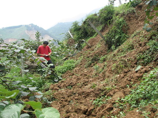 This photo shows a large scarp developed on this 'slow-slip' fault during the Wenchuan earthquake of 2008 in China. Source: http://seismosoc.org/publications/BSSA_html/bssa_100-5b/2009316-esupp/b/b.html This photo shows a large scarp developed on this 'slow-slip' fault during the Wenchuan earthquake of 2008 in China. Source: http://seismosoc.org/publications/BSSA_html/bssa_100-5b/2009316-esupp/b/b.html Great, I hear you say, I am in one of those low seismicity areas! That is what a lot of Cantabrians thought before September 2010. Well, Beware of slowly slipping faults! So reads the title of an article in Nature Geoscience in 2013. Nature Geoscience is the premiere specialist journal for geoscience articles. The article’s author, Pei-Zhen Zhang, points out that the fault zone that hosted the devastating Wenchuan earthquake in China in 2008 had been assigned a relatively low seismic hazard, because it slips slowly. (That is to say that the amount of displacement seen in a single earthquake takes a long time to accumulate, particularly compared to typical plate boundary faults like the Alpine fault.) Well, as you can see below, it might have been slow-slipping but its time was up and the displacement was impressive.
A more complete description of the fault that caused the Wenchuan earthquake would include not only the fact that it accumulates its load very slowly, but that the rocks that bound the fault are very strong. Zhang points out that incomplete scientific knowledge of the structure, earthquake history and dynamics of the Longmen Shan faults had contributed to a false sense of security in terms of seismic hazard prior to the Wenchuan earthquake. China and the world has now learnt that slow-slip faults are dangerous, and none have learnt that lesson better than Cantabrians. Why? Because the situation that Zhang describes in the Longmenshan also describes Canterbury very well. Much of Canterbury is not mountainous and the skiiers have a ways to go to do their thing in the plains. This is because the Canterbury crust deforms very slowly! It is also very strong. The stronger the crust, the more elastic energy it accumulates before fault rupture, resulting in a more energetic earthquake. Slow moving faults have plenty of time to heal between earthquakes, becoming stronger and able to accumulate greater amounts of elastic energy. The earthquakes that rocked Canterbury since the 4th September 2011 all occured on slow-slip faults and in strong crust. Ultimately, anybody living anywhere in New Zealand should be prepared to deal with the consequences of a catastrophic earthquake, whether on the Alpine Fault, sometime in the next 50 years, or on some relatively small or large, slow slipping fault that has not previously been identified.
0 Comments
Leave a Reply. |
BrendanTectonics and earthquakes Archives
February 2021
Categories |
 RSS Feed
|
Life is too short to look at ugly rocks
|